johnny haeusler mal extrem witzig. zwei seiten lang zerpflückt er lebensweisheiten, die auf bilder montiert werden und in sozialen netzwerken verteilt werden.
„Man ist immer so alt, wie man sich fühlt.“ Kompletter Bullshit. Man ist so alt, wie man alt ist. Andernfalls wäre ich gestern 72, vorgestern 13 und vorvorgestern 35 gewesen, wie soll man denn da Geburtstag feiern?
ralf heimann hat dann aber noch einen drauf gesetzt mit dieser montage:
#boschholdinghands with #evaadele. Of course this was my personal @berlinartweek highlight.
kurzkritik tomorrowland: pathetischer, total verzwirbelter und humorloser ami-kitsch mit noch schalerem nachgeschmack als das ende von lost.
“Intelligence is the ability to solve problems and plants are amazingly good in solving their problems,” Mancuso noted.
Humans have five basic senses. But scientists have discovered that plants have at least 20 different senses used to monitor complex conditions in their environment.
“Plants are wonderful communicators: they share a lot of information with neighbouring plants or with other organisms such as insects or other animals. The scent of a rose, or something less fascinating as the stench of rotting meat produced by some flowers, is a message for pollinators.”
Mancuso and colleagues recorded the same signals given off from this part of the plant as those from neurons in the animal brain. One root apex may not be able to do much. But instead of having just one root, most plants have millions of individual roots, each with a single radicle.
So, instead of a single powerful brain, Mancuso argues that plants have a million tiny computing structures that work together in a complex network, which he compares to the Internet. The strength of this evolutionary choice is that it allows a plant to survive even after losing 90% or more of its biomass.
bei hoimar von ditfurt habe ich vor vielen jahren zuerst von der these gehört, dass organische systeme (also organismen) bei ausreichender komplexität mehr oder weniger zwangsläufig intelligenz nutzen (können). so als wäre intelligenz einfach da. peter möller fasst es auf philolex.de so zusammen:
Ditfurth kommt auf Basis seiner naturwissenschaftlichen Überlegungen zu der Auffassung, es gebe in der Natur Spuren der Wirksamkeit von Verstand, lange bevor Gehirne existierten. Es gebe Intelligenz in der Natur, ohne dass dafür ein Gehirn nötig sei, das sie beherbergt. Geist, Phantasie und Zielstrebigkeit habe es in der Natur von Anfang an gegeben. Nur deshalb konnte Leben, konnten Gehirne und letztlich das Bewusstsein entstehen. Es gebe lern-analoges oder intelligenz-analoges Verhalten bei sehr einfachen Organismen.
zurück zum guardian-artikel:
“This is why plants have no brain: not because they are not intelligent, but because they would be vulnerable,” Mancuso said.
aber pflanzen brauchen eben auch kein gehirn, weil sie sich (im sinne von bewussten ortswechseln) nicht bewegen. seescheiden zum beispiel haben im larvenstadium ein gering entwickeltes gehirn. sobald sie aber einen ort gefunden haben, an dem sie sich niederlassen wollen, verdauen sie ihr primitives auge und gehirn.
So, yes, in common parlance, the sea squirt “eats its own brain,” such as it is. But since the sea squirt no longer needs its brain to help it swim around or to see, this isn’t a great loss to the creature. It needs this use this now superfluous body material to help develop its digestive, reproductive, and circulatory organs.
der entscheidende punkt: gehirne (und augen) brauchen organismsmen offenbar vor allem zur bewegung. schnelle bewegung, laufen, flüchten waren möglicherweise die hauptursachen für die gehirnentwicklung. wer nicht besonders schnell reagieren muss oder weglaufen muss, braucht keins. (siehe auch bbc.com: Why would an animal lose its brain?)
nochmal jeremy hance:
Plants also largely live on a different timescale than animals, moving and acting so slowly that we hardly notice they are, indeed, reacting to outside stimuli.
das führt mich zur blödestmöglichen schlussfolgerung die man aus diesem möglicherweise grossartigen buch ableiten kann: wir essen pflanzen ohne schlechtes gewissen, weil wir die vielfalt ihres lebens und fühlens nicht erkennen können. so gesehen basiert vegetarismus, oder nahrungsauswahl nach ethischen massstäben, eigentlich auf einem wahrnehmungsproblem.
früher™, als die alternativen noch nicht so weit verbreitet waren, hab ich genau das gemacht: ich habe das programm der privaten genutzt und die werbespots geblockt. die adblocker hiessen damals videorekorder, fernbedienung und pinkelpause.
Der Tag, an dem wir darüber nachdenken, wie wir weiter wachsen können, wird der Tag sein, an dem Vice nicht mehr funktioniert.
vice-gründer shane smith:
Wir werden nicht das nächste CNN sein oder das nächste MTV, wir werden zehnmal größer, daran arbeiten wir.
ganz allgemein gesprochen: wenn redaktionen bilder verwenden würden, die nicht von den firmen, über die sie berichten, gestellt werden, würde das meiner meinung nach journalistisch ein bisschen unabhängiger wirken.
jetzt könnte man natürlich sagen, aus rechtlichen, finanziellen oder organisatorischen gründen sei man auf die zulieferung von bildern von firmen (die zufällig auch potenzielle werbekunden sein könnten) angewiesen, aber das wäre dann gleichzeitig auch ein eingestädnis von abhängigkeit oder zumindest angewiesenheit.
wie weit sich das im rechtlichen rahmen bewegt, einfach selbst screenshots aus dem film zu machen über den man berichtet, weiss ich nicht. ich vermute die firmen werden da schnell kiebig, wenn man text-bebilderung genauso unabhängig angeht, wie die texte selbst.
Folks on iOS 9 can now block the loading of all web fonts with one setting. Make sure your site looks great anyway. pic.twitter.com/1A4oe6iTDO
zur erklärung: ich poste (fast) alles was ich auf facebook (oder twitter) hinterlasse auch in meinem blog. dieser artikel zum beispiel ist hier auf facebook. obwohl, nein das ist ein schlechtes beispiel, weil ich den artikel nicht im volltext auf facebook gepostet habe. aber dieser artikel auf wirres.net ist hier auf facebook.
kommentare unter den facebook-kopien werden zum grossen teil auch auf wirres.net gezogen, ebenso die likes und favs. wie das geht habe ich mal sehr detailreich erklärt.
der entscheidende punkt ist aber, dass ich meine notizen nicht exklusiv auf facebook posten und dort aus den augen und kontrolle verlieren will. so wächst das archiv meine öffentlichen äusserungen eben nicht nur auf facebook, sondern auch bei mir zuhause. das gleiche gilt für instagrambilder und tweets.
Jetzt bin ich bei der Benutzung von OwnYourGram mit den Endpoints für authorization und tokens fertig geworden. Aber irgendwas scheint mit den microformats nicht zu stimmen. Mal diese, mal jene Fehlermeldung - vielleicht funzen Photo-Posts mit meinem Theme nicht kompatibel. Das so kurze Erklärung für den Crossposting-Spam auf diversen Kanälen so heute um die die Mittagspause. Dabei habe ich den ganzen Kram von wegen Indieweb und Webmentions noch gar nicht erwähnt. Was mir aber kaum Wissensvorsprung vor Euch verschafft. Ich dilettier hier mit copy/paste Codeschnitzeln rum, mal wieder inspiriert von wirres.net/. Erklären kann ich das überhaupt nicht.
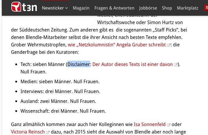
stefan niggemeier erklärt, warum man blendle toll finden kann:
Wer einen irgendwie spektakulären Artikel aus der Print-Ausgabe einer Zeitung oder eines Magazins lesen wollte, musste die ganze Zeitung kaufen — oder warten, bis er vielleicht später doch noch kostenlos veröffentlicht wurde. (Manche Inhalte, wie etwa die renommierten Seite-3-Geschichten der „Süddeutschen“, erschienen aber grundsätzlich nicht online, aus der Logik, dass sie kostbar bleiben sollten.)
Blendle ändert das jetzt endlich. Wenn ich einen gelungenen Artikel aus einer gedruckten Zeitung empfehlen will, muss ich ihn nicht als Foto bei Twitter oder Facebook veröffentlichen (wie das absurderweise oft genug passiert). Und ich muss die Leser nicht zum Kiosk schicken oder zum Kauf irgendwelcher Tagespässe oder E-Paper-Ausgaben animieren. Ich kann ihn direkt verlinken, und man kann ihn für wenige Cent kaufen, und wenn man bei Blendle registriert ist, sogar mit einem Klick.
der „kleine Haken“ sind eigentlich viele kleine haken: die preisgestaltung, die import-qualität von print-artikeln (in der launch phase der letzten wochen ist das auf blendle eher schlimmer, als besser geworten) und artikel die auf blendle kosten, aber eventuell frei im netz verfügbar sind.
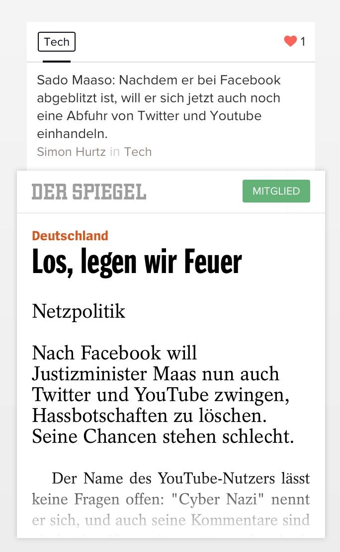
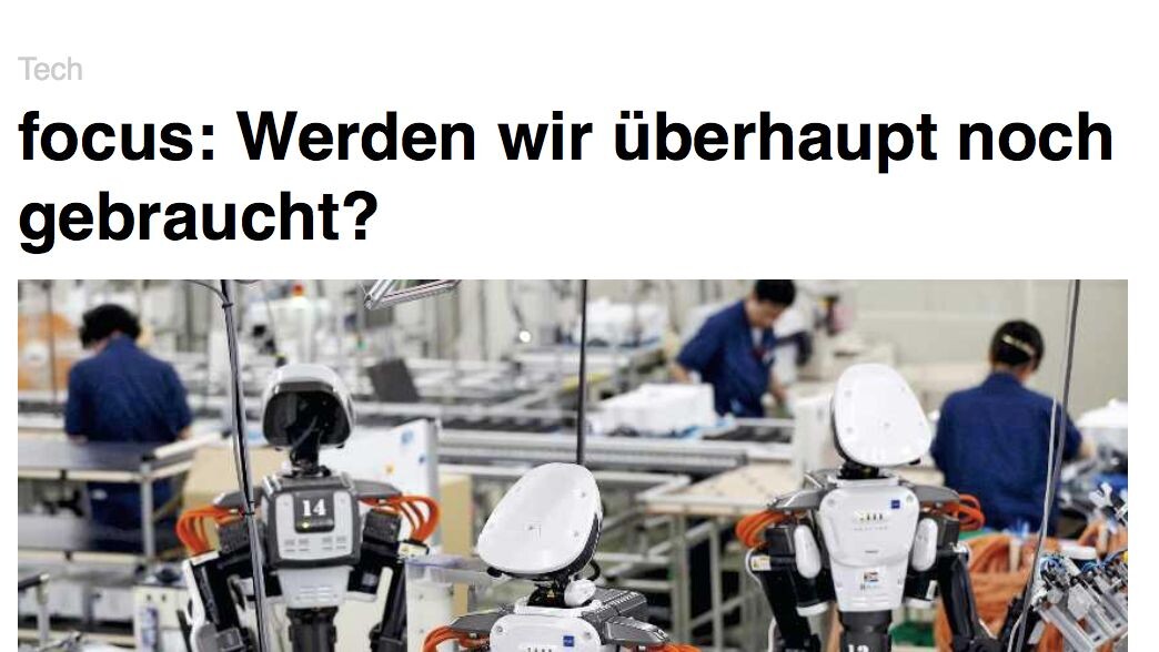
braucht den focus noch jemand, oder kann der weg? (aus dem blendle newsletter)


